A New Perspective on the Construction Site
Construction projects are in a constant state of transformation. Ground is excavated, foundations appear, structures rise and façades close in, often within a matter of weeks. Capturing this rapid evolution accurately has always been a challenge. Traditional surveying, manual measurements and periodic site walks provide valuable information, but they are time-consuming and limited by human vantage points.
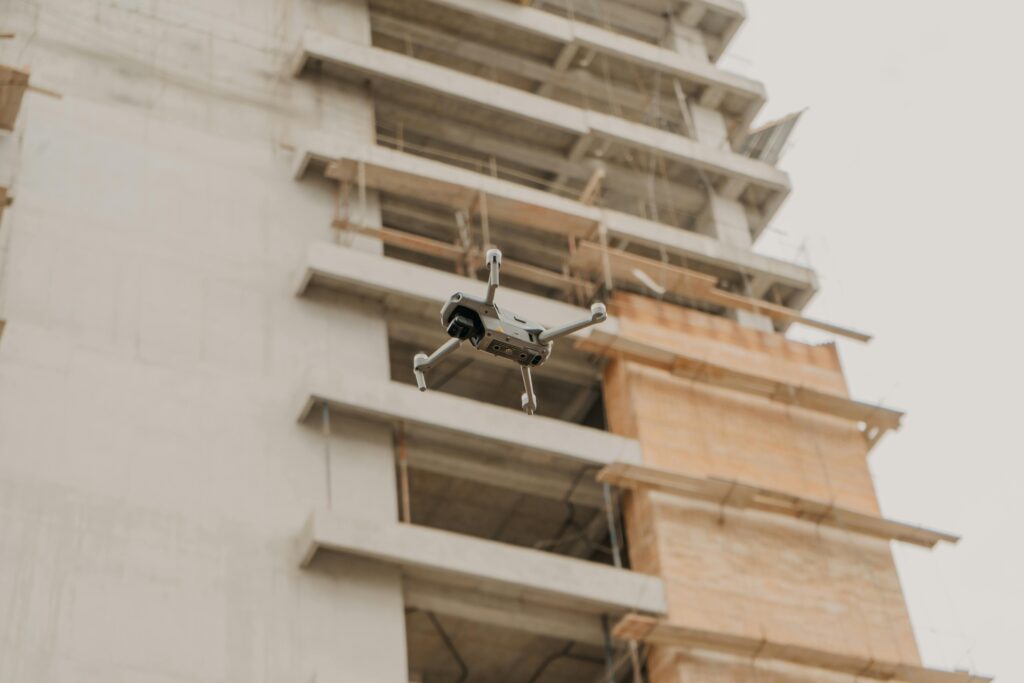
Drones have introduced a radically different way of seeing the site. In a single short flight, a drone can capture hundreds of high-resolution images covering every corner of the project. From these images, detailed aerial maps and three-dimensional models can be produced that show the site exactly as it exists at that moment in time.
On their own, these visuals are impressive. However, the real transformation occurs when drone data is integrated directly into construction management software. At that point, aerial imagery stops being a collection of photographs and becomes part of the project’s decision-making system. The site is no longer just observed; it is continuously measured, compared and analysed against the plan.
From Pictures to Measurable Reality
A key advantage of drone capture is consistency. Flights can be repeated on the same path and at the same altitude each week, creating a reliable visual record of change over time. When images are stitched into orthomosaic maps, every pixel represents a precise real-world location and scale.
When this map is overlaid with design drawings or BIM models inside construction software, the comparison between planned and actual becomes immediate. Managers can see not just that work has progressed, but exactly where and by how much. Earthworks volumes can be calculated to verify quantities moved. Slab extents can be measured to confirm poured areas. Temporary works and access routes can be checked against agreed layouts.
This turns visual observation into quantifiable evidence. Instead of relying on subjective impressions of progress, teams work with measurable data that can be tracked week by week. Small deviations from plan become visible early, when they are easiest to correct.
Continuous Progress Monitoring Without Disruption
Traditional progress verification often interrupts the work itself. Surveyors must access active areas, measurements must be taken manually and parts of the site may need to be temporarily cleared. Drone capture avoids most of this disruption. Flights take place above the work and typically last only minutes.
Because the process is fast and repeatable, monitoring can occur frequently. Weekly or even daily flights create a near-continuous timeline of the build. When these updates are uploaded straight into the project platform, progress dashboards refresh with current information rather than lagging behind reality.
Remote stakeholders benefit particularly from this immediacy. Clients, consultants and senior managers can review the latest aerial view without travelling to site. Discussions about progress shift from abstract percentages to shared visual evidence. Everyone sees the same current state of the project, reducing misunderstanding and debate.
Early Detection of Quality Issues
High-resolution aerial imagery is not limited to tracking quantities and areas. It also supports quality assurance. Large surfaces such as roofs, façades and external works can be inspected visually at a level of detail that is difficult to achieve safely from ground level.
Potential defects, incomplete sections or misalignments can be spotted before they are concealed by subsequent works. When such issues are identified, they can be logged directly within the construction management system, linked to the exact location on the aerial map and assigned for correction. Photographic evidence from the drone becomes part of the formal quality record.
Because flights are repeated, it is easy to confirm that rectification has occurred. The next survey provides an updated view of the same location, closing the feedback loop without waiting for a site visit from every stakeholder involved.
Smarter Coordination Between Trades
Complex sites can be difficult to interpret from two-dimensional drawings alone, especially for stakeholders who are not present every day. Drone-generated maps provide a shared spatial reference that everyone can understand immediately.
When linked to digital drawings and issue tracking, the aerial view becomes a navigation layer for coordination. A trade can see exactly where another team is working and how that affects access or sequencing. Temporary storage areas, crane locations and haul routes are visible in context, helping prevent clashes before they occur.
This shared visual context is particularly valuable for remote collaboration. Video calls and online reviews become more effective when participants can point to the same live map rather than describe locations verbally. Decisions about logistics and sequencing are grounded in the actual, current layout of the site.
Enhancing Safety Planning and Verification
Safety management depends heavily on understanding site layout. Access paths, exclusion zones, plant routes and emergency points must be correctly positioned and maintained as the site evolves. Drone imagery makes it straightforward to verify these elements regularly.
Aerial views reveal whether barriers, edge protection and traffic controls are installed as intended. Changes in layout that might create new risks become visible quickly. If a temporary works arrangement drifts from the approved plan, corrective action can be requested immediately.
Because flights can be archived over time, safety reviews can also look backwards. Investigations benefit from being able to see exactly how the site was configured on a given date. This historical record supports learning and continual improvement rather than relying on memory alone.
Building a Time-Based Record of the Project
One of the most powerful aspects of regular drone capture is the creation of a chronological visual record. Each flight becomes a snapshot in the project’s history. When stored and indexed within construction software, these snapshots can be browsed like a timeline.
This historical perspective is invaluable for resolving disputes and clarifying responsibility. Questions about when a condition first appeared or whether an area was accessible at a certain time can be answered with dated imagery rather than recollection. Claims discussions become evidence-based rather than speculative.
The same record supports future planning. Reviewing how previous stages actually unfolded helps refine sequencing on later phases or on entirely new projects. Lessons that might otherwise be forgotten are preserved in visual form.
Integration as the Multiplier of Value
Drone data stored separately from the rest of the project information quickly becomes just another disconnected dataset. Its real value emerges when it sits alongside drawings, RFIs, schedules and issue logs in the same platform.
Integrated access allows seamless movement from a task or issue to the latest aerial view of that exact location. A manager reviewing a delay can immediately check current site conditions. A designer responding to a query can confirm surrounding works visually before issuing guidance.
This integration reduces friction in decision-making. Stakeholders do not need to switch between tools or request additional images. The information required to judge a situation is available in one place, in context and up to date.
Supporting Remote and Multi-Site Management
For organisations overseeing several projects, drones combined with centralised software create consistent visibility across all sites. Senior leaders can review progress and conditions on multiple jobs within a single interface, without constant travel.
This consistency also improves benchmarking. When each project is monitored using the same aerial and digital methods, comparisons of productivity, safety and sequencing become more meaningful. Best practice identified on one site can be shared and replicated on others.
Remote management becomes practical rather than risky. Decisions are based on current visual data rather than delayed reports, allowing confident guidance even at a distance.
Operational Discipline for Reliable Insights
To gain full benefit, drone operations must be repeatable and well organised. Consistent flight paths, heights and camera settings ensure that comparisons between dates are accurate. Standard processing and upload procedures keep data flowing quickly enough to influence live work rather than only retrospective analysis.
Clear ownership of the workflow is essential. Whether managed in-house or by a specialist provider, someone must be responsible for capturing, processing and publishing each survey on schedule. Predictability builds trust in the data and encourages teams to rely on it for decisions.
Compliance and safety considerations must also be respected. Flights should follow relevant aviation and site safety regulations, and communication with site teams should ensure that aerial operations never conflict with ongoing work.
Enabling Better Communication with Clients and Stakeholders
Clients and external stakeholders often struggle to visualise progress from written reports alone. Drone-derived visuals translate technical updates into intuitive images. Overlaying planned and actual extents shows achievement clearly and transparently.
Regular visual updates can reduce the need for frequent physical visits, saving time while maintaining confidence. Stakeholder discussions move from abstract status descriptions to shared visual evidence, strengthening trust and alignment.
For public or community-facing projects, carefully curated aerial imagery can also support broader communication, helping non-specialists understand how the development is evolving.
From Periodic Surveys to a Living Digital Twin
As drone capture becomes more automated and processing more immediate, the gap between reality and its digital representation continues to shrink. Regular surveys integrated directly into project software effectively create a living digital twin of the site.
In this environment, deviations from plan are detected almost as soon as they occur. Progress is continuously validated rather than periodically checked. Decisions are made with reference to current conditions rather than last week’s recollection.
This does not eliminate the need for boots on the ground, but it ensures that every physical action is supported by up-to-date spatial understanding. The site is both built and observed in parallel.
Transforming Observation into Intelligent Control
Drones provide the eyes in the sky. Construction management software provides the structured memory and workflow of the project. When these two capabilities are combined, site monitoring evolves from occasional observation into continuous, intelligent control.
Visual data becomes measurable, measurable data becomes actionable and actionable insight becomes timely decisions. Progress, quality, safety and coordination all benefit from the same integrated aerial perspective.
In a sector where seeing the real condition of the work is often the difference between delay and momentum, the partnership between drones and digital project platforms is more than a technological upgrade. It is a practical step towards projects that are understood in real time and managed with confidence at every stage.
In today’s construction landscape, efficiency and accuracy are paramount. Construction management software, like Wunderbuild, revolutionises project handling by centralising tasks, from scheduling and budget management to communication and document control. This integration enhances productivity and ensures projects are completed on time and within budget, making it an essential tool for modern construction professionals. Embrace Wunderbuild here to begin streamlining your construction processes and boost your project’s profitability.